
Optics Mag is reader-supported. When you buy via links on our site, we may earn an affiliate commission at no cost to you. Read more.
3 Types of Satellite Imagery in 2026 (With Pictures)
Last Updated on

The first satellite image of Earth was captured in 1959 by Explorer 6. The satellite’s primary mission was to study electrical and magnetic fields in the upper atmosphere, but it was also equipped with devices to record cloud cover. That first image, which was of the Pacific Ocean, took 40 minutes to be relayed back to a ground station in Hawaii, and the image is virtually unrecognizable.
Today, satellite imagery is much more advanced and thanks to the hundreds of image-taking satellites that orbit the planet, we can map and record every inch of the planet twice a day, images are readily and freely available via services like Google Earth, and satellite imagery is used for a variety of purposes from tracking weather patterns to mapping and for warfare and defense.
There are three primary types of satellite imagery used that record visible light, infrared light, and water vapor data.

Top 3 Types of Satellite Imagery:
1. Visible
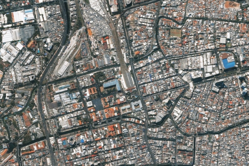
Visible images are what we think of as typical photographs. They reveal a close approximation to what we see with the naked eye. These images are actually recording sunlight as it reflects off surfaces and when you look at Google Earth, you are viewing visible light satellite images.
Visible imagery is only effective during daylight hours. At night, there is no reflected sunlight in the area, so the satellite is unable to capture any images. There are other limitations with visible light imagery, too. Different objects reflect different amounts of sunlight.
Those objects that reflect the least light appear darker in the images, while those that reflect the most light will appear brighter. There can be some confusion in the images produced, especially when clouds and ice are photographed. They can appear the same, making it difficult to differentiate between cloud cover and ice or snow. Viewing a series of pictures taken seconds apart can help—clouds move, while snow and other freezing surfaces do not move.
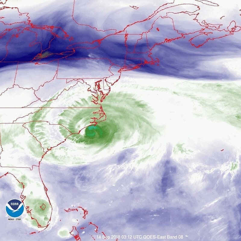
2. Infrared

The limitations of visible imagery make infrared imaging especially useful. All objects with a temperature above absolute zero radiate energy, and infrared detects the difference in wavelengths produced by objects of different temperatures.
Infrared imagery does not use visible light or reflected light, which means that it can be used to gather data at night as well as during the day.
However, as with visible light imagery, there are limitations to infrared imagery. For example, when used for meteorology, some cloud types and fog have a similar temperature to that of the Earth’s surface, which means that they will appear a similar color in the resulting images. When this is the case, infrared imagery is combined with other data and potentially other types of images to create a reliable, overall picture.
3. Water Vapor
The final common type of satellite imagery used is water vapor imagery. This effectively detects the level of moisture in the atmosphere or humidity level. It can detect the level at which moisture is present, from the upper troposphere to ground level. Dry areas show a different color than those areas with water vapor, and different shades indicate the actual level of water vapor.
Conclusion
Satellite imagery is a powerful tool in earth sciences, especially used in meteorology. It is also used in cartography and military planning, and it has extensive commercial uses. There are thousands of active satellites, many of which relay imagery data back to Earth, and some of this data can be freely accessed via services like Google Earth and also via agencies including NASA.
The main types of satellite imagery used are those that use visible light, infrared, and water vapor. There has been an increase in the number of satellites that are capable of recording video and there are likely to be new variations of satellites launched in the coming years.
Featured Image Credit: Gorodenkoff, Shutterstock
About the Author Robert Sparks
Robert’s obsession with all things optical started early in life, when his optician father would bring home prototypes for Robert to play with. Nowadays, Robert is dedicated to helping others find the right optics for their needs. His hobbies include astronomy, astrophysics, and model building. Originally from Newark, NJ, he resides in Santa Fe, New Mexico, where the nighttime skies are filled with glittering stars.
Related Articles:
Monocular vs Telescope: Differences Explained (With Pictures)
How to Clean a Refractor Telescope: Step-by-Step Guide
How to Clean a Telescope Eyepiece: Step-by-Step Guide
How to Clean a Rifle Scope: 8 Expert Tips
What Is a Monocular Used For? 8 Common Functions
How to Clean a Telescope Mirror: 8 Expert Tips
Brightfield vs Phase Contrast Microscopy: The Differences Explained
SkyCamHD Drone Review: Pros, Cons, FAQ, & Verdict